The Route
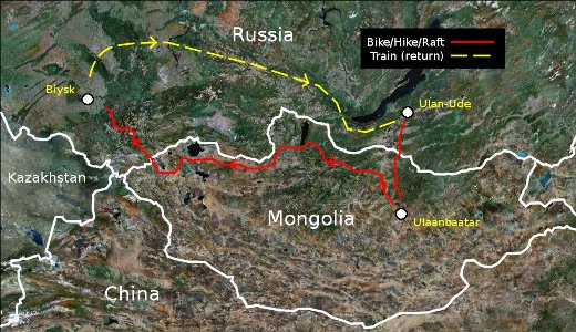 The capital city of Ulaanbaatar is the official launching point but the real adventure begins 200 miles northwest in the small town of Erdenet where the pavement ends and the “road” begins. Another 240 miles west by northwest over gravel surface and dirt track lies the village of Erdenebulgan, where the team will break west over open country following the Eg river (fording by raft at times) before making an ascent on foot to the degree confluence positioned at 50°N 101°E at an altitude of 2020m (6627 ft). The expedition continues westward and north through the
mountains to the eastern shore of Lake Khövsgöl... (route overview)
The capital city of Ulaanbaatar is the official launching point but the real adventure begins 200 miles northwest in the small town of Erdenet where the pavement ends and the “road” begins. Another 240 miles west by northwest over gravel surface and dirt track lies the village of Erdenebulgan, where the team will break west over open country following the Eg river (fording by raft at times) before making an ascent on foot to the degree confluence positioned at 50°N 101°E at an altitude of 2020m (6627 ft). The expedition continues westward and north through the
mountains to the eastern shore of Lake Khövsgöl... (route overview)
Commitment to Conservation
 Our team strongly supports the International Union for Conservation of Nature (IUCN) and its mission to preserve biodiversity at both the global and local level. It is our goal to contribute as much to the WDPA as possible within the scope of the expedition; consequently, the team is looking forward to working more closely with the WDPA development team to maximize the efectiveness of our data collection efforts. We would like to express our gratitude to Dr. Paul F.J. Eagles, Margaret E. Bowman, and Teresa Chang-Hung Tao of the University of Waterloo for their work on the IUCN publication Guidelines for Tourism in Parks and Protected Areas of East Asia. The
collective efforts of the aforementioned researchers have provided a firm foundation for developing a standard of conduct for our team as well as a benchmark for evaluating the success of existing Protected Area management practices in Mongolia.
Our team strongly supports the International Union for Conservation of Nature (IUCN) and its mission to preserve biodiversity at both the global and local level. It is our goal to contribute as much to the WDPA as possible within the scope of the expedition; consequently, the team is looking forward to working more closely with the WDPA development team to maximize the efectiveness of our data collection efforts. We would like to express our gratitude to Dr. Paul F.J. Eagles, Margaret E. Bowman, and Teresa Chang-Hung Tao of the University of Waterloo for their work on the IUCN publication Guidelines for Tourism in Parks and Protected Areas of East Asia. The
collective efforts of the aforementioned researchers have provided a firm foundation for developing a standard of conduct for our team as well as a benchmark for evaluating the success of existing Protected Area management practices in Mongolia.
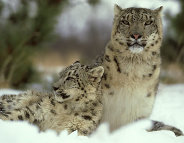
Photo by Alan And Sandy Carey.
The Road Less Taken
 Yes, that's right- biking, hiking, and rafting. Sure you can cross Mongolia in a jeep or even by bicycle alone if you stick to what passes for a road (usually a washboarded dirt track), but you'd be missing the point. One goal of the expedition is to develop travel resources for future visitors to enhance their experience of the natural beauty of Mongolia's wilderness in an environmentally conscious manner. Data recorded along the way will include navigational waypoints and tracks (from both GPS data and clear-day compass sightings of notable land features), select river fords and low water crossings, and locations of key resources such as potable water sources and places to dispose of refuse responsibly. Compiling this body of research requires significant travel off the grid and (in a country the size of Alaska with only 364 bridges) that's not possible without a raft. Select segments of
the journey will demand travel on foot out of respect for the delicate nature of this pristine wilderness.
Yes, that's right- biking, hiking, and rafting. Sure you can cross Mongolia in a jeep or even by bicycle alone if you stick to what passes for a road (usually a washboarded dirt track), but you'd be missing the point. One goal of the expedition is to develop travel resources for future visitors to enhance their experience of the natural beauty of Mongolia's wilderness in an environmentally conscious manner. Data recorded along the way will include navigational waypoints and tracks (from both GPS data and clear-day compass sightings of notable land features), select river fords and low water crossings, and locations of key resources such as potable water sources and places to dispose of refuse responsibly. Compiling this body of research requires significant travel off the grid and (in a country the size of Alaska with only 364 bridges) that's not possible without a raft. Select segments of
the journey will demand travel on foot out of respect for the delicate nature of this pristine wilderness.
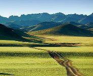
Photo by Lucie's Photography.
Why Mongolia?
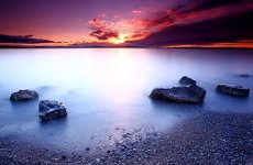 That's easy. Look at a couple of photos and discover just a few facts about Mongolia and it's love at first site for any outdoor enthusiast. Check out this shot of Lake Khovsgul at sunset.
Photo by Lucie's Photography.
But seriously- wouldn't you rather defend our resources with education and awareness rather than attempt reclamation after the damage is done? "Mongolia faces several significant environmental threats, including mining, deforestation, off-road vehicle use, pollution, rapid human population growth, expanding livestock numbers, poaching, and rapid socioeconomic and cultural change associated with the recent shift from communism to a free-market democracy."
The team of the Mongolia by Bicycle Quest is dedicated to promoting awareness of tourism environmental impact and increasing our understanding of current Protected Area management to help preserve what remains of our planet's unspoiled natural treasures. Lend your support by donating or joining the team.
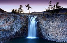
Dusk at Orkhon Khurkhree Waterfall
Photo by Lucie's Photography.
